|
|


|
|
|
.
Blue Line:
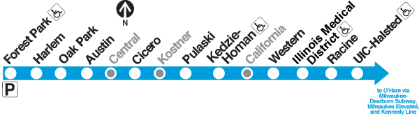
Forest Park (Congress) branch
 |
||||||||||
|
Legend:
Click on a station name to see that station's profile (where available) |
|
|
|
|
|
.
Blue Line:
Forest Park (Congress) branch
|
|
||||||||||
|
Legend:
Click on a station name to see that station's profile (where available) |
Service Notes:
| Hours of Operation: Service at all times | ||
| Length of Route: 8.7 miles | ||
Number of Stations: 11 stations, plus 3 abandoned stations |
||
| Car Types Assigned: 2600-series, 3200-series, 5000-series*, 7000-series (see Car Assignment sheet for latest car assignments) | ||
| * 5000-series cars assigned to 54th Yard, run lite to Blue Line for rush period trips | ||
Brief Description:
The first rapid transit line completely designed in the Chicago Transit Authority era-- the Milwaukee-Dearborn Subway, opened in 1951, had been designed before the CTA took control of Chicago transit operations -- pioneered new design philosophies, in terms of both route and station design.
Extending about 9.5-miles west from downtown Chicago, the Congress Line, or "West Side Subway" as it was also called in some informational and publicity materials its early years, was built to replace the 50+ year old Garfield Park elevated, whose removal was required by the construction of the Congress Superhighway (later called the Eisenhower Expressway, originally Interstate 90 and now I-290). The new, replacement line followed an innovative new concept: putting a rapid transit line in the center of a multi-lane, grade-separated expressway.
Many publicity materials for the Congress Line issued by the city and the CTA, as well as media stories and industry journals of the time, trumpeted the project as the first time a mass transit rail line had been put in the median of an expressway. For instance, a commemorative booklet issued by the city called the Congress Line "the first significant project providing rail rapid transit in the grade-separated right-of-way of a multi-lane automobile expressway"; other materials used similar superlatives. Whether this is accurate or not is somewhat subjective, and may largely rest on semantics of the specific wording used. The most direct rival for pioneering this concept is probably Cahuenga Pass Parkway in Los Angeles, a 3-mile long six-lane freeway that ran through the Cahuenga Pass between Hollywood and Studio City. Opening in 1940, the Cahuenga Parkway featured Pacific Electric Railway "Red Car" tracks in its median. One could argue that the PE Red Car was an interurban, not rapid transit; or that, while a multi-lane limited-access grade-separated roadway, the Cahuenga Pass route was a parkway, not an expressway. (It is also worth noting that the Red Car line in the parkway was discontinued in December 1952, and the tracks removed in 1957-58, so it no longer existed as an example by the time the Congress Line opened. Today, the former rail right-of-way has been taken over by additional traffic lanes on the roadway, which is now part of the US 101 Hollywood Freeway.)
Whatever the case, Chicago's concept of combining an expressway and a rapid transit line in the same alignment attracted worldwide attention, and transit operators, transit and highway engineers, and public officials from all over the United States and Canada came to Chicago to observe the project design firsthand. Indeed, this concept was not only duplicated again twice in Chicago on the Dan Ryan and Kennedy lines, but became a accepted design concept used all over the US on several different transit systems.
The reasons for constructing a rapid transit line within the grade-separated right-of-way of a multi-lane expressway were multi-fold. First, it was believed it would create a "transportation corridor", bringing both efficiency of land use and attracting the most commuters to multiple modes of transport. It would allow minimize the amount of high-value land in dense metropolitan areas that has to be removed from its tax-producing status when compared to a multi-lane expressway and a rapid transit line being built on separate alignments.
Second, there was a cost savings in putting the rapid transit line in the grade separated right-of-way of a multi-lane auto expressway: it increased carrying capacity of the corridor for relatively little cost. The cost distribution was one-fifth for transit facilities and four-fifths for the expressway, effectively providing a cleared and graded right-of-way for the transit line without the line having to bear the cost , providing "the maximum in passenger transport for every dollar spent," according to the City of Chicago at the time. Federal highway matching contributed to financing the cost of the right-of-way and the increased length of local street overpass bridges. The City of Chicago, using both highway funds and bonds of its own issue, constructed the transit line and a portion of the expressway between the Chicago River and Laramie Avenue (5200 West). The City would also pay for the new yard and terminal facilities at Desplaines Avenue in Forest Park, replacing the Garfield Park yard and terminal at Laramie Avenue within the City of Chicago. Cook County and the State of Illinois, using highway funds, constructed the portion between Laramie Avenue and Desplaines Avenue because the construction of the expressway in this section compelled the relocation of the Garfield Park track and station infrastructure.
The new right-of-way was also a straighter route with station stops spaced farther apart and protected with automatic block signals, providing a faster, safer ride. Running time between the Loop and Forest Park was reduced 17 minutes compared with the Garfield Park service operated in September 1953 before construction of the Congress Line began and by about eight minutes compared to the temporary street-level operation used during the duration of construction. The new alignment also eliminated 28 street grade crossings once the new line was completed all the way into Desplaines terminal. One railroad grade crossing, which often caused delays to service, was also eliminated.
Although the Congress Line was commonly called the West Side Subway in its planning phase and early years of operation, most of it was a subway only in so much as it was below street level, but was not encased within an enclosed subterranean tube. Only the easternmost three-quarters of the line were, in fact, a true subway: an extension of the Milwaukee-Dearborn-Congress Subway was constructed from just west of LaSalle/Congress (200 West) to just east of Halsted Street (800 West) to connect with the Congress Superhighway right-of-way. From Halsted Street to Laramie Avenue (5200 West), a distance of approximately six miles, the Congress Line was located in the median strip of the depressed, grade-separated Congress Expressway. Just west of Laramie, between Lotus and Lockwood avenues, the two tracks curved southwest in a short tunnel under the eastbound lanes of the expressway to a right-of-way paralleling the highway, nestled between the expressway and the Baltimore and Ohio Chicago Terminal railroad right-of-way to the south. The Congress Line followed this alignment for three miles until Lathrop Avenue, where the tracks crossed over the expressway and over Desplaines Avenue to gain access to the terminal and yard. This alignment, however, was opened in stages.
Important Dates:
|
|
This Chicago-L.org article is a stub. It will be expanded in the future as resources allow. |
.
|
|
|
