The Cicero Avenue station house is seen looking west on March 9, 2007. The facility's design was standard for Congress Line stations. Except for the doors and overhead entrance sign, it is little altered from its 1958 opening. For a larger view, click here. (Photo by Graham Garfield)
|
Cicero
(4800W/720S)
Cicero Avenue and
Eisenhower Expressway, Austin
Service
Notes:

|
Blue Line:
Forest Park
|

|
Owl
Service
|
Quick Facts:
|
Address:
|
720 S. Cicero Avenue
(Cicero
entrance)
|
|
721 S. Lavergne Avenue
(Lavergne
entrance, closed)
|
Established: June 22, 1958
Original Line: West-Northwest Route, Congress Line
Previous Names: none
|
Skip-Stop Type:
|

|
Station
|
Rebuilt: n/a
Status: In Use
History:

Passengers leave the Cicero
"L" station, transferring to a Marmon-Herrington-built
trolley bus, on December 20, 1960. The neon sign was
standard on Congress "L" stations; besides its removal, the
station has been altered little. For a larger view, click here. (CTA photo) |
The original Cicero station, built as part of the Metropolitan West Side "L"'s Garfield Park branch in 1895, was demolished in the mid-1950s along with the rest of the Met "L" main line and Garfield Park branch when the Congress Street Expressway was
constructed. The plan included a novel concept: a rapid transit line
in the median of an expressway, making a sort of transit corridor.
The "new" Congress Line thus provided no net mileage gain for the "L"
system, though the facility would be newer and capable of providing faster service.
The old Met Cicero station was located one block north of the Cicero Congress station.
Cicero is nearly identical to every other station built in the
Eisenhower Expressway, including an island platform, small station
houses on the adjacent overpasses containing only a ticket booth and
turnstiles, and a long, enclosed, sloping passageway/ramp connecting
the station houses and platform. A brochure, published by the City of Chicago to commemorate
the initiation of service June 22, 1958, describes the stations this
way:
Each station platform in the expressway
right-of-way is the island type, 600 feet long and canopied
throughout its entire length. Supported by structural aluminum
columns, the canopy extends beyond the platform edge and over the
roofs of cars....
Station design on the Congress Line is somewhat unique, resulting from a
compromise between the historic concept of closely spaced stations
(favored by aldermen) and widely spaced stations, coordinated with
bus feeder routes (preferred by CTA planners anxious to improve
transit service and system productivity). The fare collection
buildings are about 42 ft x 21 ft. The stops were typically located
between two cross bridges about a 1/4-mile apart, with a
station house and access ramp at each end. On Cicero station's east end is its namesake street; on the west is
Lavergne Avenue (actually a pedestrian bridge over the expressway that connects to Lavergne
at each end). While there are obvious
disadvantages to the long ramp concept, the compromise design did
avoid the additional stops the CTA planners hoped to get rid of.
Lavergne Park 'n' Ride
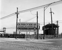
By October 1958, the CTA opened a park 'n' ride lot on part of the former site of Laramie Yard on the discontinued Garfield Park Line. The lot was added for the convenience of patrons of the then-new Congress branch of the West-Northwest Route, and located near the Cicero station.

A promo sign for the Lavergne park 'n' ride lot beckons patrons on the corner of Laramie and Harrison, on the former site of Laramie Yard, looking southeast on March 27, 1959. For a larger view, click here. (CTA photo) |
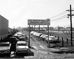
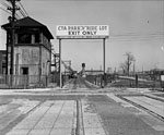
The parking lot, approximately 50 feet wide and 500 feet in length, was actually located in the area formerly occupied by the right-of-way of the discontinued Garfield Park rapid transit route, immediately east of the yard. The entrance fronted on Lavergne Avenue, one-half block north of the Cicero station's Lavergne auxiliary entrance. The exit driveway passed through the former yard site along the alignment of the removed main line tracks and exited onto Laramie Avenue.
The lot, which could accommodate 80 automobiles, was surfaced with cinders and diagonal parking stalls were marked off. Construction costs of approximately $8,500 included cinders, paved driveways, bumper ties, adequate lighting and appropriate directional and informational signs. Some of the yard infrastructure remained, however, at least for a few years, including the old interlocking tower at the west end of the outbound platform along Laramie Avenue.
When the lot opened, the CTA said that as more parking space was needed, the balance of the right-of-way extending to Laramie Avenue, including the former yard site, could be made available for more parking, but this does not appear to have taken place.
The Lavergne park 'n' ride lot appears to have been closed some time between 1965 and 1967, as it appeared on the former edition of the CTA system map but was absent from the latter.
Lavergne Entrance Fire, Closure

The inside of the reopened Lavergne station house is seen on January 25, 1973. Most of the interior has been cleared out, with high fencing confining access to just a narrow passage through an exit rotogate. For a larger view, click here. (CTA photo, Graham Garfield Collection) |
The Lavergne entrance was severely damaged by fire on September 4, 1972, with the ticket agent's booth destroyed. By early October 1972, the Lavergne station was reopened as an exit but with minimal repairs – the damaged agent's booth, turnstiles, and most of the fare control fencing had been removed, but soot still covered the walls and ceiling, and damaged sign boxes remained. A temporary gate channeled passengers though the rotogate in the northeast corner of the interior, but the public otherwise had access to the entirety of the damaged interior.
By mid-November, the interior had been significantly cleaned, the ceiling repainted, and new lights installed. The windows and doors were removed from the front storefront, and a series of full-height metal gates were installed to create a narrow passageway along the north edge of the interior, through the rotogate, but closing off the rest of the interior from public access.
A number of other stations and station entrances were closed on January 13, 1973 as an economy move, and this is listed as Lavergne's official closure date as an entrance, but in effect it had been the date of the fire in 1972. By late January 1973, the original neon promo sign over the entrance had been removed and replaced with a simple sign instructing passengers to enter the station on Cicero, at the "next bridge east".
As the CTA continued to have budget problems and further retrenchment was required, the Lavergne was closed as an exit well on Monday May 16, 1977. From that point, the front of the station house was fully barricaded at street level and the bottom of the ramp was closed off at platform level.

The Cicero station platform is seen looking east on March 9, 2007. The concrete island platform with a gullwing canopy supported by a single row of center beams is typical of all the Congress Line stations. Cicero's is little changed from when it opened in 1958. For a larger view, click here. (Photo by Graham Garfield)
|

 |
cicero.lavergne01.jpg (86k)
The Lavergne Avenue entrance to the Cicero station is seen on the pedestrian bridge over the expressway, which connects to its namesake street on each end, on May 13, 1958, a little over a month before the station opened. The Lavergne station house was unusual in being the only Congress Line entrance not on a street/roadway. (Later, a third entrance would be added to U of I-Halsted on a bridge formerly for Peoria Street but vacated to be a pedestrianway.). The scale of the neon and backlit promo sign over the entrance seems even larger in the context of the smaller, narrower bridge. (CTA photo, Graham Garfield Collection) |
 |
LavergneParkingLot01.jpg (229k)
The Lavergne park 'n' ride lot is seen looking west from the Lavergne Avenue entrance on March 27, 1959. The lot is on the land formerly occupied by the Garfield Park main line tracks; the actual yard site proper is a few hundred feet ahead. The old inspection shop is still standing, visible in the background. The lot was very simply laid, paved with cinders and gravel. Signage points to the Lavergne entrance to the new Cicero Congress station, a 1/2-block to the south. (CTA photo) |
 |
LavergneParkingLot03.jpg (278k)
The exit from the Lavergne park 'n' ride lot onto Laramie Avenue is seen looking eastward on March 27, 1959. The driveway from the lot to Laramie cut through the former yard site. Although much of the yard, including most trackage, has been cleared, several remnants remain, including an interlocking tower on the left (one of three that originally served the yard complex) and the rails still embedded in Laramie Avenue's pavement. (CTA photo) |
 |
cicero02.jpg (171k)
Riders can be seen boarding a Loop-bound St. Louis-built 6000-series train on a Congress-Milwaukee A run on December 20, 1960. Passengers disembarking at Cicero (or any other station) wishing to transfer to a bus had to have their paper transfers stamped by red time stamper machines mounted on poles at most "L" platforms or station houses. (CTA photo) |
 |
cicero.lavergne03.jpg (94k)
The Lavergne station house is seen on February 7, 1973, after being cleaned up and reopened following a fire the previous September. The front windows and doors have been removed and replaced with high-level gates to restrict access to the interior -- the facility was reopened as an exit only, with passage through a narrow corridor through the station house and access controlled by a rotogate. The original 1958 promo sign over the entrance, which had been damaged (although possibly from vandalism rather than the fire) has been recently removed and replaced by a simple unlit sign in the CTA's then-new Helvetica-typeface KDR-style. (CTA photo, Graham Garfield Collection) |
 |
cicero.lavergne04.jpg (336k)
The Lavergne station house, now closed completely to passenger use, is seen looking north on September 18, 2003. Originally closed with a plywood wall over the entrance, chainlink fencing was later installed in front of the building, with electrical equipment installed between the fence and the building. (Photo by Graham Garfield) |
 |
cicero04.jpg (221k)
The interior of the Cicero station house is seen on March 9, 2007, looking west at the fare controls from the unpaid area. Much of the original design remains, including the glazed block walls and the original ticket agent's booth. One small section of the original fare control fencing and gates, with its "wavy" metal grille panels, remains over the agent's booth. (Photo by Graham Garfield) |

- Cicero_Blue-FP.wav
(55k): "This is Cicero."
(Sound courtesy of Tony Coppoletta)
.
- Cicero_Blue-FP_doors.wav
(281k): "Doors open on the left at Cicero. Priority seating is
intended for the elderly and passengers with disabilities. Your
cooperation is requested."
(Sound courtesy of Tony Coppoletta)


